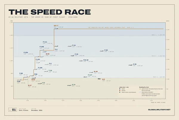
The Speed Race
25 US military jets placed by first flight and top speed: the speed frontier steps up to the SR-71 in December 1964 and stays flat ever since.
$39 Free US shipping
20 large-format posters charted from the GlobalMilitary.net database: aircraft, navies, nuclear arsenals, air bases and insignia, each plate fact-checked against its sources.
25 US military jets placed by first flight and top speed: the speed frontier steps up to the SR-71 in December 1964 and stays flat ever since.
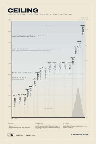
18 US military aircraft at their service ceilings, from the UH-60 at 19,000 ft to the SR-71 above 85,000, climbing a cross-section of the sky with the tropopause, the Armstrong line and the air pressure beside them.
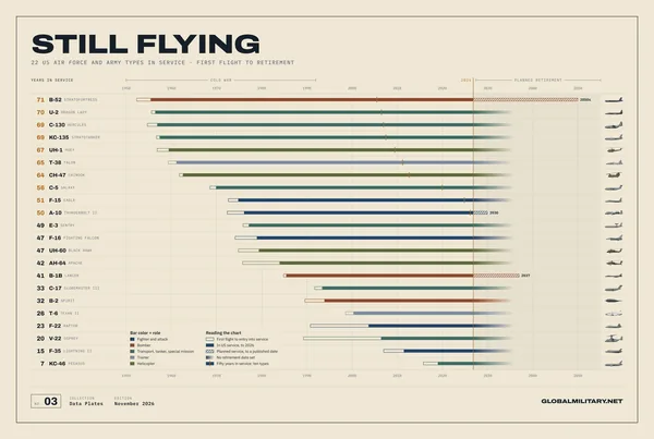
22 US Air Force and Army aircraft types, each from first flight to entry into service, its years in US service and a planned retirement where one is published; ten have served fifty years.
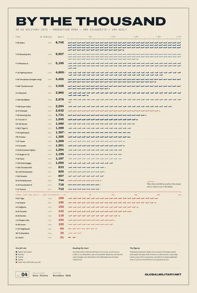
38 US military jets counted in silhouettes of a hundred, from the 8,745 F-86 Sabres to the 21 B-2s, the rarest types counted in tens.
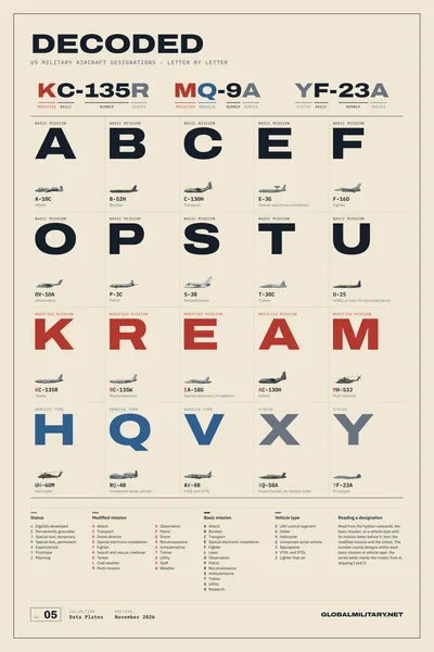
The 1962 Tri-Service system that names every US military aircraft, read position by position: three worked examples, twenty letters each shown on an aircraft that carries it, and the complete symbol lists.
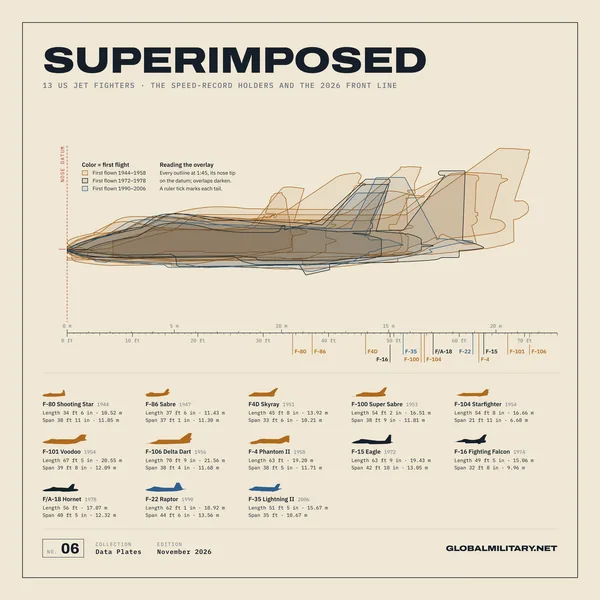
13 US fighters from the F-80 to the F-35, side profiles laid over each other at 1:45, noses on one point: the fighter doubles in length in twelve years, then stops growing.
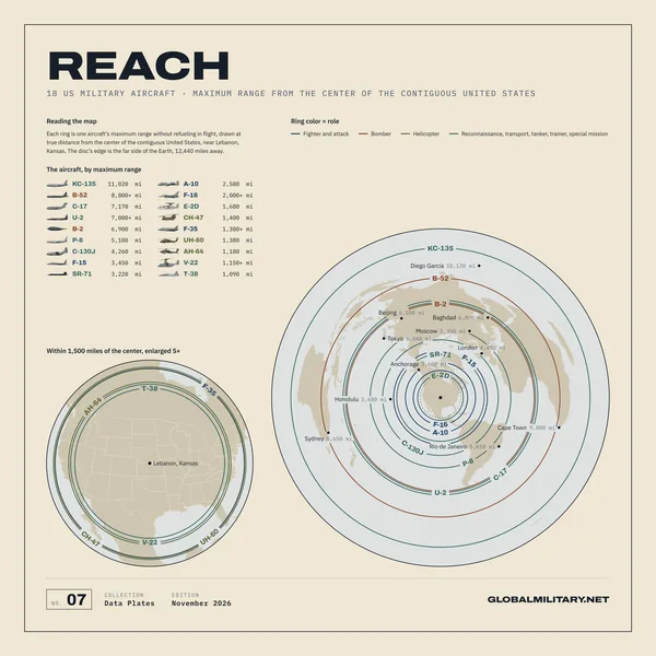
18 US military aircraft as rings of true distance from the center of the contiguous United States, from the T-38 to the KC-135.
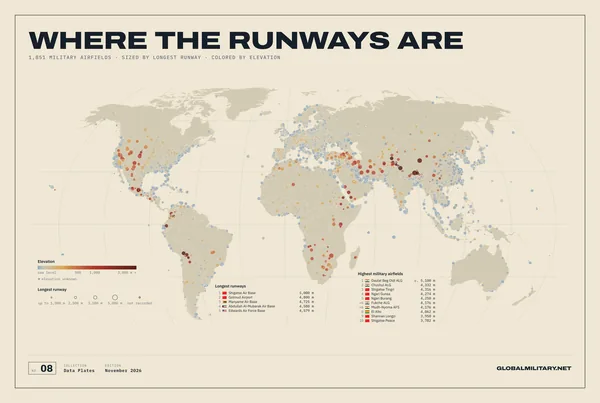
Every military airfield on one world map, 1,851 of them: dots sized by runway length and colored from sea level to the Tibetan plateau.
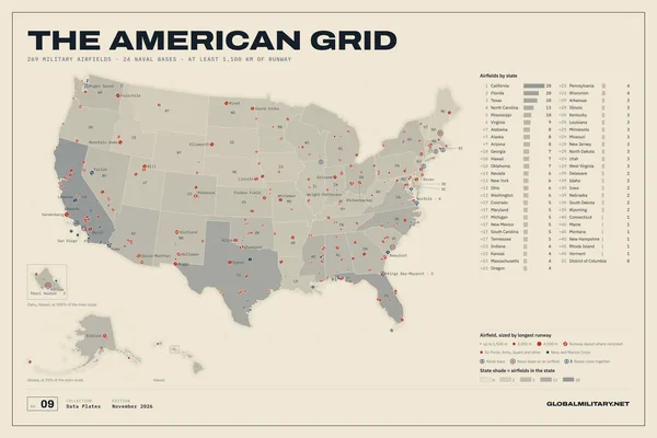
269 military airfields and 24 naval bases across the fifty states: discs sized by the longest runway with the runway layout drawn inside, the 30 longest runways named and every state ranked beside the map.
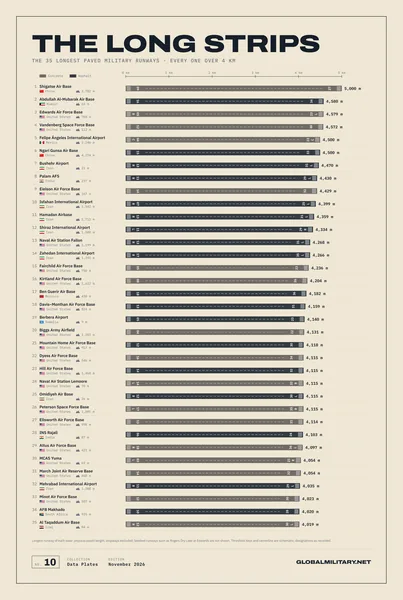
The 35 military runways longer than 4 km, drawn as strips at 1:12,500: a ruler of concrete from Shigatse to Al Taqaddum.
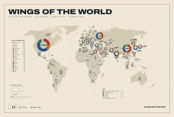
The military aviation of 160 countries as proportional discs on the map, each split by role: the American giant, the Chinese and Russian pair, and the long tail.
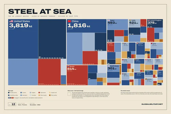
The twenty largest navies as a mosaic of warship tonnage, every block subdivided by ship type, from carriers to coastal craft.
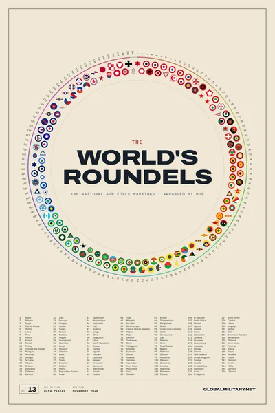
146 national air force roundels on one hue wheel, red to violet and then monochrome, with a numbered key beneath.
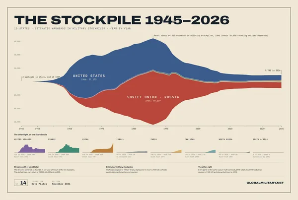
Eighty years of nuclear warheads as one stream: the 1986 peak of about 64,500, the long decline, and the eight smaller arsenals on their own scale.
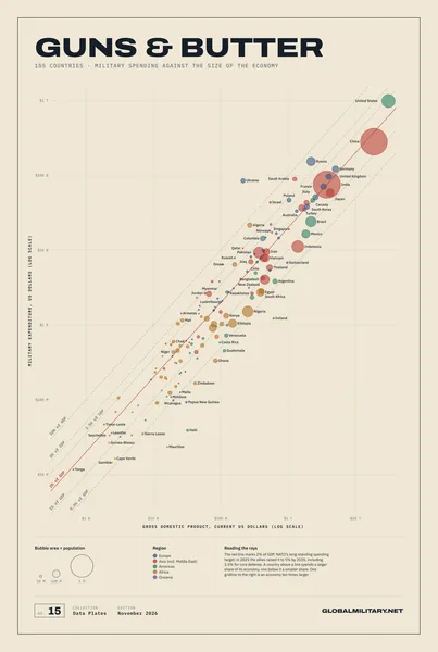
155 defense budgets set against the size of their economies, with rays from 0.5 % to 10 % of GDP and the 2 % NATO line in red.
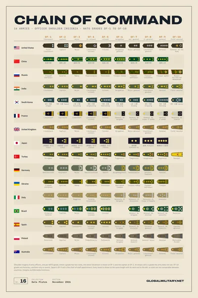
Sixteen armies and ten NATO officer grades: a matrix of real shoulder insignia, read across to climb, down to compare.
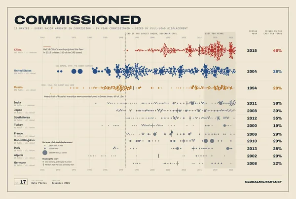
Every major warship of 12 navies as one dot at the year it joined the fleet: half of China's fleet joined in 2015 or later, nearly half of Russia's is Soviet.
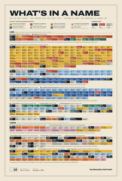
Every named hull of the US Navy, 393 tiles colored by what its namesake is known for; each ship type states its naming rule, and the color shows where it breaks.
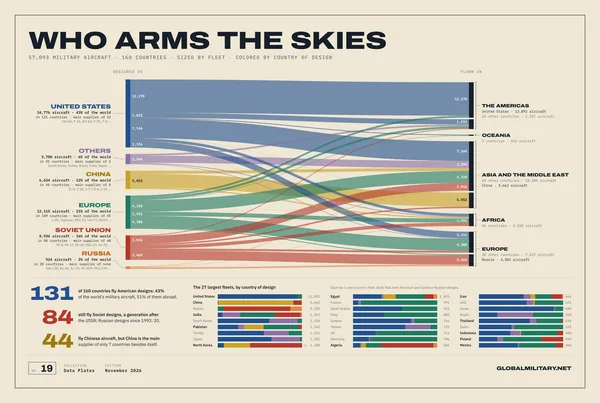
Every military aircraft in 160 countries, traced from the country that designed it to the region that flies it: American designs in 131 countries, Soviet ones in 84 a generation after the USSR.
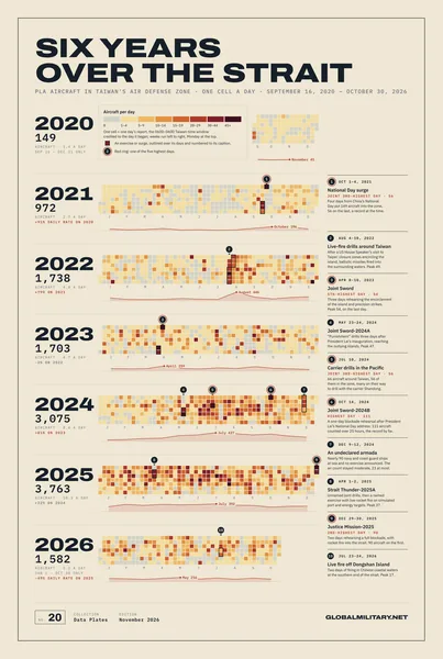
Every day from September 2020 to October 2026 as one cell of a calendar: the daily count of PLA aircraft in Taiwan's air defense identification zone, the major exercises outlined and captioned.
Every figure comes from the data behind GlobalMilitary.net and is checked plate by plate against its sources.
Your poster is printed when you order it, on 200 g/m² premium matte paper at 300 dpi, at a print facility in the United States.
Rolled and shipped in a protective tube, free across the United States. A damaged or misprinted print is reprinted free.